Fleet Management System & GPS Fleet Tracking
Unify GPS fleet tracking, driver scoring, geofencing and fuel monitoring into one vendor-agnostic fleet telematics platform built for the UAE and GCC.
Book a demoThe live dashboard, in motion
This is the actual TAKEOVR operations view for Fleet Management — live status, telemetry and alerts updating in real time. No mock-ups, no slideware.
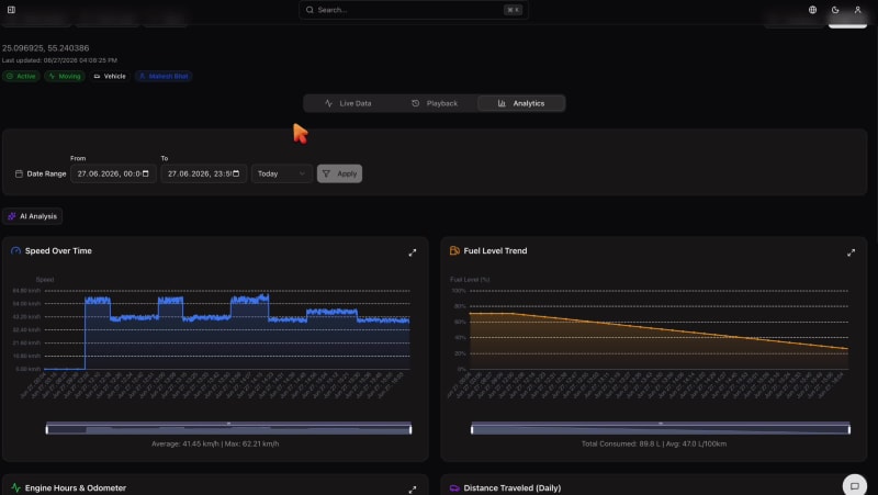
One platform for every vehicle in your fleet
Most fleets are not short of data, they are short of a single place to use it. Trackers from different vendors, fuel sensors, maintenance spreadsheets and dispatch tools all live in separate silos, so managers spend their day stitching information together instead of acting on it. The result is fuel that disappears without explanation, vehicles that sit idle while others are overworked, and safety incidents that are only understood after the fact.
TAKEOVR brings the entire fleet into one operational picture. We ingest live telemetry from the GPS and telematics hardware you already run, normalize it across brands, and turn it into live maps, driver scorecards, geofence alerts and utilization reports. Because the platform is vendor-agnostic, you keep your existing investment in devices and avoid the lock-in that comes with single-brand telematics.
Everything you need to run a connected fleet
Real-time GPS fleet tracking
Watch every vehicle on a live map with second-by-second position, heading, speed and ignition status. Replay historical trips, review stops and reconstruct any journey for dispute resolution or compliance.
Driver behavior & safety scoring
Detect harsh braking, rapid acceleration, sharp cornering, speeding and excessive idling. Turn raw events into a per-driver safety score you can use for coaching, incentives and insurance evidence.
Geofencing & zone control
Draw geofences around depots, sites, customer locations and restricted areas. Get instant entry, exit and dwell alerts, plus after-hours movement detection to curb unauthorized use.
Fuel monitoring & loss prevention
Track fuel level, consumption and refuelling events from CAN-bus or fuel-level sensors. Surface sudden drops that signal theft or leaks and benchmark consumption across drivers and routes.
Trips, routes & utilization
Automatic trip logging, mileage and engine-hour accounting, and utilization reporting reveal idle assets, overloaded vehicles and opportunities to right-size the fleet.
Vendor-agnostic hardware
Onboard Teltonika, Queclink, Milesight and OEM CAN-bus feeds without committing to one supplier. Mix devices across the fleet and manage them all from one normalized data model.
How TAKEOVR fleet management works
Connect your hardware
Point existing trackers or new devices at TAKEOVR. We parse and normalize their feeds into a unified data model.
Map and organize
Group vehicles, assign drivers, draw geofences and configure the alerts and reports that matter to your operation.
Monitor in real time
Track location, behavior and fuel live, while automated rules flag exceptions before they become costs.
Act on the data
Coach drivers, schedule maintenance and optimize routes using utilization, safety and cost analytics.
Utilization reports that write themselves
The Vehicle Utilization report consolidates distance, fuel consumed and filled, average and maximum RPM, harsh-driving counts and engine hours across your fleet — grouped daily, weekly or monthly. AI reads it and tells you which vehicles and drivers need attention, in plain language.

Top & bottom performers, named
The AI surfaces your most and least efficient vehicles and highest-risk drivers by name, so coaching and maintenance go where they matter.
Fuel & harsh-driving trends
It connects rising fuel consumption to idling, speeding and harsh-driving counts, pointing at the behavior behind the cost.
Recommended actions, not just charts
Every report ends with concrete next steps, ready to export to PDF for your weekly ops review and board packs.
Stop building utilization reports by hand. TAKEOVR turns raw telemetry into a narrative your team can act on the day it lands.
Telematics that pays for itself
Strong fleet telematics pays for itself in three ways: lower fuel and maintenance costs, fewer accidents and claims, and better asset utilization. By making harsh-driving events, idling, route deviations and fuel anomalies visible the moment they happen, TAKEOVR lets you intervene while it still matters rather than reading about it in a month-end report.
The same platform that tracks your vehicles also monitors stationary and industrial assets, so logistics yards, on-site fuel tanks and standby generators can all be managed alongside the fleet. That unified view is what turns scattered telematics into a single source of truth for the whole operation.
Your whole operation, in your pocket
Managers track the live fleet map on the move, drivers pick up assigned work orders, and everyone sees alarms the moment they fire.
- Live vehicle map
- Driver & geofence alerts feed
- Work orders on the go
- Analytics tab
- In-app messaging

Frequently asked questions
A fleet management system is software that consolidates GPS location, engine telemetry, driver behavior and maintenance data from every vehicle into a single operational view. TAKEOVR ingests live data from on-board telematics devices, normalizes it across mixed hardware, and presents it as live maps, trip histories, utilization reports and automated alerts so operators can run a safer, more cost-efficient fleet.
Yes. TAKEOVR is deliberately vendor-agnostic. We parse data from common telematics units such as Teltonika, Queclink and Milesight, as well as OEM CAN-bus feeds, so you are not locked into a single hardware brand. If you already have trackers installed, we can usually onboard them without ripping out and replacing your fleet hardware.
TAKEOVR analyzes telematics signals such as harsh acceleration, hard braking, cornering, speeding against posted or geofenced limits, and idling. Each driver receives a composite safety score that managers can use for coaching, recognition and insurance reporting. Scoring is configurable, so you can weight the events that matter most to your operation.
Yes. You can draw circular or polygon geofences around depots, customer sites, restricted zones or city limits and receive entry, exit and dwell-time notifications. Route and schedule deviations, unauthorized after-hours movement and prolonged stops can all trigger real-time alerts by dashboard, email or webhook into your existing systems.
TAKEOVR is built for operators across the UAE, Saudi Arabia, Egypt and the wider GCC and MENA region, with multilingual support including English and Arabic. The platform runs in the cloud and works wherever your vehicles have cellular coverage, with map and address resolution tuned for regional road networks.
See TAKEOVR on your own assets
Book a live walkthrough and we will show you how TAKEOVR connects your existing hardware into one monitoring platform.
Book a demo